FLOOD RISK
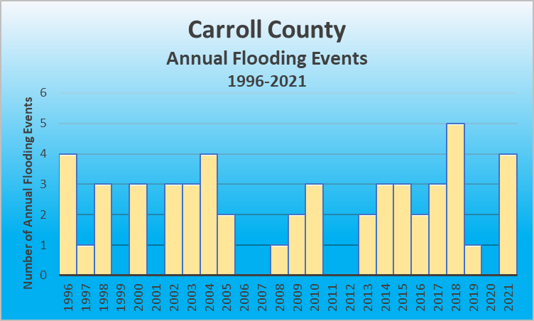
According to the 2020 Census, Carroll County covers 128.57 sq miles with a population of 10,810. As a county bordering the Ohio River and incorporating the Kentucky River within its boundaries, Carroll County is at high risk for flooding. This is evidenced by FEMA’s 4 federal disaster declarations for flooding since 1953.Flooding events January 1, 2016 – December 31, 2021
| Location | County/Zone | St. | Date | Time | T.Z. | Type | Mag | Dth | Inj | PrD | CrD |
|---|---|---|---|---|---|---|---|---|---|---|---|
| ENGLISH | CARROLL CO. | KY | 08/01/2016 | 12:20 | EST-5 | Flash Flood | 0 | 0 | 0.00K | 0.00K | |
| CARROLLTON | CARROLL CO. | KY | 08/01/2016 | 12:20 | EST-5 | Flash Flood | 0 | 0 | 0.00K | 0.00K | |
| EAGLE STATION | CARROLL CO. | KY | 04/29/2017 | 08:00 | EST-5 | Flash Flood | 0 | 0 | 0.00K | 0.00K | |
| PRESTONVILLE | CARROLL CO. | KY | 05/20/2017 | 20:00 | EST-5 | Flash Flood | 0 | 0 | 0.00K | 0.00K | |
| CARROLLTON | CARROLL CO. | KY | 05/24/2017 | 18:30 | EST-5 | Flood | 0 | 0 | 0.00K | 0.00K | |
| CARROLLTON | CARROLL CO. | KY | 02/24/2018 | 20:28 | EST-5 | Flash Flood | 0 | 0 | 0.00K | 0.00K | |
| CARROLLTON | CARROLL CO. | KY | 09/09/2018 | 02:15 | EST-5 | Flood | 0 | 0 | 0.00K | 0.00K | |
| WORTHVILLE | CARROLL CO. | KY | 09/09/2018 | 02:15 | EST-5 | Flood | 0 | 0 | 0.00K | 0.00K | |
| EAGLE STATION | CARROLL CO. | KY | 09/09/2018 | 06:00 | EST-5 | Flood | 0 | 0 | 0.00K | 0.00K | |
| SANDERS | CARROLL CO. | KY | 09/09/2018 | 14:00 | EST-5 | Flood | 0 | 0 | 0.00K | 0.00K | |
| CARROLL CO. | CARROLL CO. | KY | 06/09/2019 | 20:43 | EST-5 | Flood | 0 | 0 | 0.00K | 0.00K | |
| EAGLE STATION | CARROLL CO. | KY | 02/28/2021 | 11:00 | EST-5 | Flood | 0 | 0 | 0.00K | 0.00K | |
| SANDERS | CARROLL CO. | KY | 02/28/2021 | 23:00 | EST-5 | Flood | 0 | 0 | 6.00K | 0.00K | |
| SANDERS | CARROLL CO. | KY | 03/01/2021 | 00:00 | EST-5 | Flood | 0 | 0 | 0.00K | 0.00K | |
| CARROLLTON | CARROLL CO. | KY | 06/18/2021 | 23:30 | EST-5 | Flood | 0 | 0 | 0.00K | 0.00K |
For details on each flooding event, click here to go to the NOAA website for flooding events in Carroll County Kentucky.
FLOOD RISK
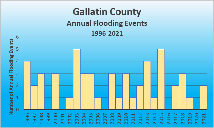
According to the 2020 Census, Gallatin County covers 101.23 sq miles with a population of 8,775. As a county bordering the Ohio River, Gallatin County is at high risk for flooding. This is evidenced by FEMA’s 2 federal disaster declarations for flooding since 1953.Flooding events January 1, 2016 – December 31, 2021
| Location | County/Zone | St. | Date | Time | T.Z. | Type | Mag | Dth | Inj | PrD | CrD |
|---|---|---|---|---|---|---|---|---|---|---|---|
| ETHRIDGE | GALLATIN CO. | KY | 05/24/2017 | 18:30 | EST-5 | Flash Flood | 0 | 0 | 0.00K | 0.00K | |
| ETHRIDGE | GALLATIN CO. | KY | 05/24/2017 | 18:45 | EST-5 | Flash Flood | 0 | 0 | 0.00K | 0.00K | |
| SPARTA | GALLATIN CO. | KY | 02/24/2018 | 20:35 | EST-5 | Flash Flood | 0 | 0 | 0.00K | 0.00K | |
| SPARTA | GALLATIN CO. | KY | 09/09/2018 | 02:30 | EST-5 | Flood | 0 | 0 | 0.00K | 0.00K | |
| SPARTA | GALLATIN CO. | KY | 09/09/2018 | 12:30 | EST-5 | Flood | 0 | 0 | 0.00K | 0.00K | |
| WARSAW | GALLATIN CO. | KY | 02/07/2019 | 16:12 | EST-5 | Flood | 0 | 0 | 0.00K | 0.00K | |
| GLENCOE | GALLATIN CO. | KY | 02/28/2021 | 11:00 | EST-5 | Flood | 0 | 0 | 2.00K | 0.00K | |
| SUGAR BAY | GALLATIN CO. | KY | 02/28/2021 | 11:00 | EST-5 | Flood | 0 | 0 | 3.00K | 0.00K |
 For details on each flooding event, click here to go to the NOAA website for flooding events in Gallatin County Kentucky.
FLOOD RISK
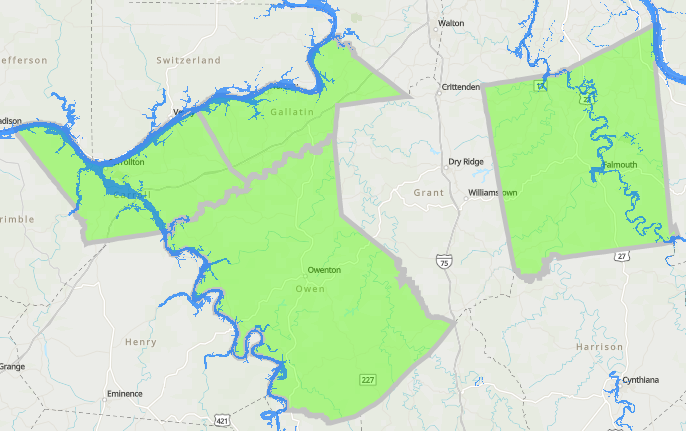
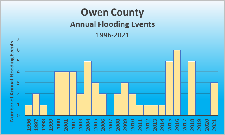
According to the 2020 Census, Owen County covers 101.23 sq miles and has a population of 11,294. As a county with communities bordering the Kentucky River, Owen County is at risk for flooding. This is evidenced by FEMA’s 5 federal disaster declarations for flooding since 1953.Use the map below to see where your home/business lies in relation to watershed areas.
| Location | County/Zone | St. | Date | Time | T.Z. | Type | Mag | Dth | Inj | PrD | CrD |
|---|---|---|---|---|---|---|---|---|---|---|---|
| TERESITA | OWEN CO. | KY | 05/01/2016 | 15:40 | EST-5 | Flash Flood | 1 | 0 | 50.00K | 0.00K | |
| CULL | OWEN CO. | KY | 06/23/2016 | 16:25 | EST-5 | Flood | 0 | 0 | 0.00K | 0.00K | |
| NEW | OWEN CO. | KY | 06/23/2016 | 16:45 | EST-5 | Flash Flood | 0 | 0 | 0.00K | 0.00K | |
| HARMONY | OWEN CO. | KY | 06/23/2016 | 17:00 | EST-5 | Flash Flood | 0 | 0 | 0.00K | 0.00K | |
| TERESITA | OWEN CO. | KY | 06/23/2016 | 17:00 | EST-5 | Flash Flood | 0 | 0 | 0.00K | 0.00K | |
| NATLEE | OWEN CO. | KY | 06/23/2016 | 17:00 | EST-5 | Flash Flood | 0 | 0 | 0.00K | 0.00K | |
| OWENTON | OWEN CO. | KY | 04/03/2018 | 20:00 | EST-5 | Flash Flood | 0 | 0 | 3.00K | 0.00K | |
| POPLAR GROVE | OWEN CO. | KY | 05/22/2018 | 19:30 | EST-5 | Flood | 0 | 0 | 0.50K | 0.00K | |
| MOXLEY | OWEN CO. | KY | 09/09/2018 | 02:00 | EST-5 | Flood | 0 | 0 | 0.00K | 0.00K | |
| MOXLEY | OWEN CO. | KY | 09/09/2018 | 06:00 | EST-5 | Flood | 0 | 0 | 0.00K | 0.00K | |
| SQUIRESVILLE | OWEN CO. | KY | 09/24/2018 | 15:00 | EST-5 | Flood | 0 | 0 | 0.00K | 0.00K | |
| OWENTON | OWEN CO. | KY | 02/28/2021 | 11:00 | EST-5 | Flood | 0 | 0 | 0.00K | 0.00K | |
| PERRY PARK | OWEN CO. | KY | 03/04/2021 | 15:00 | EST-5 | Flood | 1 | 0 | 0.00K | 0.00K | |
| NEW LIBERTY | OWEN CO. | KY | 06/13/2021 | 16:00 | EST-5 | Flash Flood | 0 | 0 | 30.00K | 0.00K |
 For details on each flooding event, click here to go to the NOAA website for flooding events in Owen County Kentucky.
FLOOD RISK
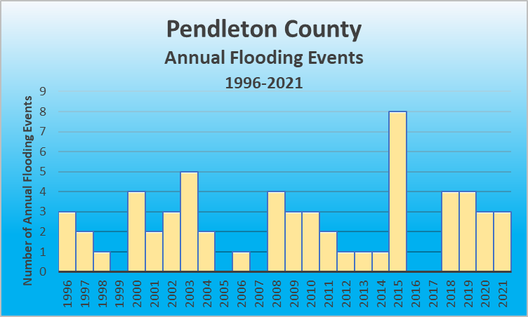
According to the 2020 Census, Pendleton County covers 277.16 sq miles and has a population of 14,607. As a county with communities containing the Licking River, and bordering the Ohio River, Pendleton County is at risk for flooding. This is evidenced by FEMA’s 2 federal disaster declarations for flooding since 1953.| Location | County/Zone | St. | Date | Time | T.Z. | Type | Mag | Dth | Inj | PrD | CrD |
|---|---|---|---|---|---|---|---|---|---|---|---|
| FALMOUTH | PENDLETON CO. | KY | 02/22/2018 | 08:42 | EST-5 | Flood | 0 | 0 | 0.00K | 0.00K | |
| MERIDIAN | PENDLETON CO. | KY | 09/08/2018 | 21:15 | EST-5 | Flood | 0 | 0 | 0.00K | 0.00K | |
| FOUR OAKS | PENDLETON CO. | KY | 09/09/2018 | 02:45 | EST-5 | Flood | 0 | 0 | 0.00K | 0.00K | |
| FALMOUTH | PENDLETON CO. | KY | 09/09/2018 | 06:00 | EST-5 | Flood | 0 | 0 | 0.00K | 0.00K | |
| KNOXVILLE | PENDLETON CO. | KY | 02/06/2019 | 13:28 | EST-5 | Flood | 0 | 0 | 0.00K | 0.00K | |
| DE MOSSVILLE | PENDLETON CO. | KY | 02/06/2019 | 13:28 | EST-5 | Flood | 0 | 0 | 0.00K | 0.00K | |
| LYNN | PENDLETON CO. | KY | 02/06/2019 | 13:28 | EST-5 | Flood | 0 | 0 | 0.00K | 0.00K | |
| PENDLETON CO. | PENDLETON CO. | KY | 06/17/2019 | 21:00 | EST-5 | Flash Flood | 0 | 0 | 25.00K | 0.00K | |
| CALDWELL | PENDLETON CO. | KY | 05/24/2020 | 16:45 | EST-5 | Flood | 0 | 0 | 0.00K | 0.00K | |
| MERIDIAN | PENDLETON CO. | KY | 05/24/2020 | 17:00 | EST-5 | Flood | 0 | 0 | 0.00K | 0.00K | |
| FOUR OAKS | PENDLETON CO. | KY | 05/25/2020 | 14:30 | EST-5 | Flood | 0 | 0 | 0.00K | 0.00K | |
| HAYES | PENDLETON CO. | KY | 02/28/2021 | 11:00 | EST-5 | Flood | 0 | 0 | 0.00K | 0.00K | |
| GREENWOOD | PENDLETON CO. | KY | 04/28/2021 | 17:30 | EST-5 | Flood | 0 | 0 | 0.00K | 0.00K | |
| BUTLER | PENDLETON CO. | KY | 04/28/2021 | 17:30 | EST-5 | Flood | 0 | 0 | 0.00K | 0.00K |
 For details on each flooding event, click here to go to the NOAA website for flooding events in Pendleton County Kentucky.
Know your Risks for Floods
An important part of preparing for a flood includes knowing your risk. You can use the map(s) above to see where your home or business lies in regard to flood zones. Knowing this can help you to know what further actions you should take such as purchasing flood insurance and preparing in advance for a flood. You can also visit FEMA’s Flood Map Service Center and enter a specific address to search.
Purchase Flood Insurance
Most homeowners’ insurance policies do not cover damage as a result of flooding. Specific flood insurance policies are available to cover those damages. If you rent rather than own, you can still get flood insurance to cover the contents of your residence in the event of a flood.
The National Flood Insurance Program is available at more than 50 insurance companies across the nation and NFIP Direct. Please note, that it can take up to 30 days for a flood insurance policy to go into effect so do not delay.
Make a Plan
Make a plan for your household including your pets so everyone knows what to do, where to go, and what you will need to protect yourselves from flooding.
|  |
To sign up for the local emergency alert system(s) in your area, click on the county below, or link to the local emergency management department Facebook page of your county.
HAZARDS
Do’s | |
|  |
Dont’s | |
|
Download FEMA’s How to Stay Safe During a Flood and take an active role in your safety!
Our homes are our lifeline to stability and connectedness with the world. As a result, we can be left feeling vulnerable and anxious when access has been disrupted. It is only natural to want to return home as quickly as possible after a flood or other natural disaster but waiting until it is safe is vital for your safety and health.
- Return home only after authorities have indicated it is safe
- Avoid driving after a flood, except in emergencies. (Roads may have washed away or debris may litter roadways and create travel hazards)
- Wear appropriate personal protective equipment when doing clean-up. Heavy duty gloves, protective clothing, and boots, and use appropriate face coverings/masks if cleaning mold or other debris.
- Children should not assist with cleanup work.
- Persons with COPD/Asthma or other lung conditions and suppressed immune systems should not be exposed to mold that is visible or can be smelled.
- Be aware of snakes and other animals that may have entered your house while the waters were high.
- Be aware of the risk of electrocution. Do not touch any electrical equipment if it is wet or if you are in standing water. Turn off the electricity to prevent shock if it is safe to do so.
- Avoid wading in flood water. Flood water can be contaminated with harmful debris and or downed power lines that can electrically charge the water.
- Use a generator or other gasoline-powered machine ONLY outdoors and away from windows.