FLOOD RISK
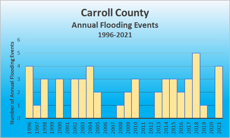
According to the 2020 Census, Carroll County covers 128.57 sq miles with a population of 10,810. As a county bordering the Ohio River and incorporating the Kentucky River within its boundaries, Carroll County is at high risk for flooding. This is evidenced by FEMA’s 4 federal disaster declarations for flooding since 1953.Flooding events January 1, 2016 – December 31, 2021
| Location | County/Zone | St. | Date | Time | T.Z. | Type | Mag | Dth | Inj | PrD | CrD |
|---|---|---|---|---|---|---|---|---|---|---|---|
| ENGLISH | CARROLL CO. | KY | 08/01/2016 | 12:20 | EST-5 | Flash Flood | 0 | 0 | 0.00K | 0.00K | |
| CARROLLTON | CARROLL CO. | KY | 08/01/2016 | 12:20 | EST-5 | Flash Flood | 0 | 0 | 0.00K | 0.00K | |
| EAGLE STATION | CARROLL CO. | KY | 04/29/2017 | 08:00 | EST-5 | Flash Flood | 0 | 0 | 0.00K | 0.00K | |
| PRESTONVILLE | CARROLL CO. | KY | 05/20/2017 | 20:00 | EST-5 | Flash Flood | 0 | 0 | 0.00K | 0.00K | |
| CARROLLTON | CARROLL CO. | KY | 05/24/2017 | 18:30 | EST-5 | Flood | 0 | 0 | 0.00K | 0.00K | |
| CARROLLTON | CARROLL CO. | KY | 02/24/2018 | 20:28 | EST-5 | Flash Flood | 0 | 0 | 0.00K | 0.00K | |
| CARROLLTON | CARROLL CO. | KY | 09/09/2018 | 02:15 | EST-5 | Flood | 0 | 0 | 0.00K | 0.00K | |
| WORTHVILLE | CARROLL CO. | KY | 09/09/2018 | 02:15 | EST-5 | Flood | 0 | 0 | 0.00K | 0.00K | |
| EAGLE STATION | CARROLL CO. | KY | 09/09/2018 | 06:00 | EST-5 | Flood | 0 | 0 | 0.00K | 0.00K | |
| SANDERS | CARROLL CO. | KY | 09/09/2018 | 14:00 | EST-5 | Flood | 0 | 0 | 0.00K | 0.00K | |
| CARROLL CO. | CARROLL CO. | KY | 06/09/2019 | 20:43 | EST-5 | Flood | 0 | 0 | 0.00K | 0.00K | |
| EAGLE STATION | CARROLL CO. | KY | 02/28/2021 | 11:00 | EST-5 | Flood | 0 | 0 | 0.00K | 0.00K | |
| SANDERS | CARROLL CO. | KY | 02/28/2021 | 23:00 | EST-5 | Flood | 0 | 0 | 6.00K | 0.00K | |
| SANDERS | CARROLL CO. | KY | 03/01/2021 | 00:00 | EST-5 | Flood | 0 | 0 | 0.00K | 0.00K | |
| CARROLLTON | CARROLL CO. | KY | 06/18/2021 | 23:30 | EST-5 | Flood | 0 | 0 | 0.00K | 0.00K |
For details on each flooding event, click here to go to the NOAA website for flooding events in Carroll County Kentucky.
FLOOD RISK
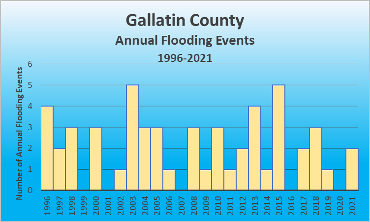
According to the 2020 Census, Gallatin County covers 101.23 sq miles with a population of 8,775. As a county bordering the Ohio River, Gallatin County is at high risk for flooding. This is evidenced by FEMA’s 2 federal disaster declarations for flooding since 1953.Flooding events January 1, 2016 – December 31, 2021
| Location | County/Zone | St. | Date | Time | T.Z. | Type | Mag | Dth | Inj | PrD | CrD |
|---|---|---|---|---|---|---|---|---|---|---|---|
| ETHRIDGE | GALLATIN CO. | KY | 05/24/2017 | 18:30 | EST-5 | Flash Flood | 0 | 0 | 0.00K | 0.00K | |
| ETHRIDGE | GALLATIN CO. | KY | 05/24/2017 | 18:45 | EST-5 | Flash Flood | 0 | 0 | 0.00K | 0.00K | |
| SPARTA | GALLATIN CO. | KY | 02/24/2018 | 20:35 | EST-5 | Flash Flood | 0 | 0 | 0.00K | 0.00K | |
| SPARTA | GALLATIN CO. | KY | 09/09/2018 | 02:30 | EST-5 | Flood | 0 | 0 | 0.00K | 0.00K | |
| SPARTA | GALLATIN CO. | KY | 09/09/2018 | 12:30 | EST-5 | Flood | 0 | 0 | 0.00K | 0.00K | |
| WARSAW | GALLATIN CO. | KY | 02/07/2019 | 16:12 | EST-5 | Flood | 0 | 0 | 0.00K | 0.00K | |
| GLENCOE | GALLATIN CO. | KY | 02/28/2021 | 11:00 | EST-5 | Flood | 0 | 0 | 2.00K | 0.00K | |
| SUGAR BAY | GALLATIN CO. | KY | 02/28/2021 | 11:00 | EST-5 | Flood | 0 | 0 | 3.00K | 0.00K |
 For details on each flooding event, click here to go to the NOAA website for flooding events in Gallatin County Kentucky.
FLOOD RISK
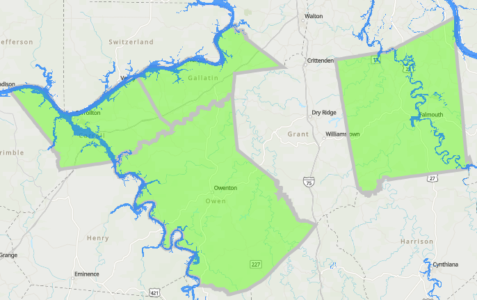
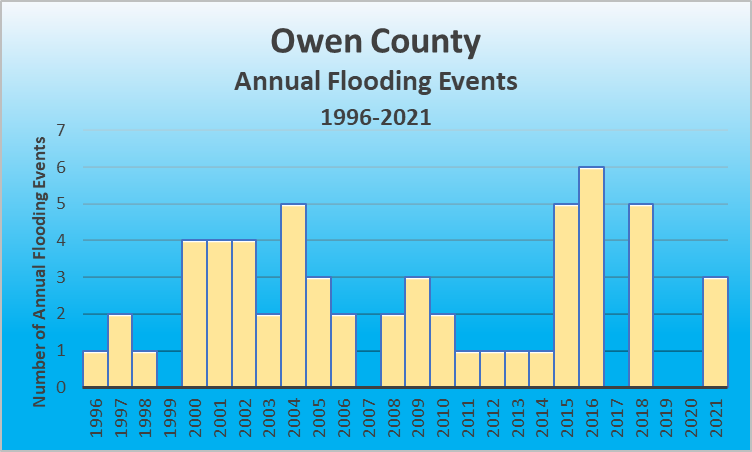
According to the 2020 Census, Owen County covers 101.23 sq miles and has a population of 11,294. As a county with communities bordering the Kentucky River, Owen County is at risk for flooding. This is evidenced by FEMA’s 5 federal disaster declarations for flooding since 1953.Use the map below to see where your home/business lies in relation to watershed areas.
| Location | County/Zone | St. | Date | Time | T.Z. | Type | Mag | Dth | Inj | PrD | CrD |
|---|---|---|---|---|---|---|---|---|---|---|---|
| TERESITA | OWEN CO. | KY | 05/01/2016 | 15:40 | EST-5 | Flash Flood | 1 | 0 | 50.00K | 0.00K | |
| CULL | OWEN CO. | KY | 06/23/2016 | 16:25 | EST-5 | Flood | 0 | 0 | 0.00K | 0.00K | |
| NEW | OWEN CO. | KY | 06/23/2016 | 16:45 | EST-5 | Flash Flood | 0 | 0 | 0.00K | 0.00K | |
| HARMONY | OWEN CO. | KY | 06/23/2016 | 17:00 | EST-5 | Flash Flood | 0 | 0 | 0.00K | 0.00K | |
| TERESITA | OWEN CO. | KY | 06/23/2016 | 17:00 | EST-5 | Flash Flood | 0 | 0 | 0.00K | 0.00K | |
| NATLEE | OWEN CO. | KY | 06/23/2016 | 17:00 | EST-5 | Flash Flood | 0 | 0 | 0.00K | 0.00K | |
| OWENTON | OWEN CO. | KY | 04/03/2018 | 20:00 | EST-5 | Flash Flood | 0 | 0 | 3.00K | 0.00K | |
| POPLAR GROVE | OWEN CO. | KY | 05/22/2018 | 19:30 | EST-5 | Flood | 0 | 0 | 0.50K | 0.00K | |
| MOXLEY | OWEN CO. | KY | 09/09/2018 | 02:00 | EST-5 | Flood | 0 | 0 | 0.00K | 0.00K | |
| MOXLEY | OWEN CO. | KY | 09/09/2018 | 06:00 | EST-5 | Flood | 0 | 0 | 0.00K | 0.00K | |
| SQUIRESVILLE | OWEN CO. | KY | 09/24/2018 | 15:00 | EST-5 | Flood | 0 | 0 | 0.00K | 0.00K | |
| OWENTON | OWEN CO. | KY | 02/28/2021 | 11:00 | EST-5 | Flood | 0 | 0 | 0.00K | 0.00K | |
| PERRY PARK | OWEN CO. | KY | 03/04/2021 | 15:00 | EST-5 | Flood | 1 | 0 | 0.00K | 0.00K | |
| NEW LIBERTY | OWEN CO. | KY | 06/13/2021 | 16:00 | EST-5 | Flash Flood | 0 | 0 | 30.00K | 0.00K |
 For details on each flooding event, click here to go to the NOAA website for flooding events in Owen County Kentucky.
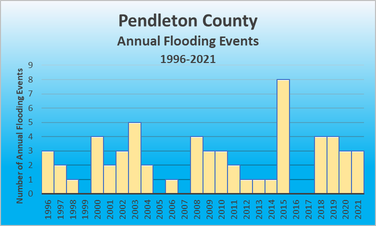
FLOOD RISK
According to the 2020 Census, Pendleton County covers 277.16 sq miles and has a population of 14,607. As a county with communities containing the Licking River, and bordering the Ohio River, Pendleton County is at risk for flooding. This is evidenced by FEMA’s 2 federal disaster declarations for flooding since 1953.| Location | County/Zone | St. | Date | Time | T.Z. | Type | Mag | Dth | Inj | PrD | CrD |
|---|---|---|---|---|---|---|---|---|---|---|---|
| FALMOUTH | PENDLETON CO. | KY | 02/22/2018 | 08:42 | EST-5 | Flood | 0 | 0 | 0.00K | 0.00K | |
| MERIDIAN | PENDLETON CO. | KY | 09/08/2018 | 21:15 | EST-5 | Flood | 0 | 0 | 0.00K | 0.00K | |
| FOUR OAKS | PENDLETON CO. | KY | 09/09/2018 | 02:45 | EST-5 | Flood | 0 | 0 | 0.00K | 0.00K | |
| FALMOUTH | PENDLETON CO. | KY | 09/09/2018 | 06:00 | EST-5 | Flood | 0 | 0 | 0.00K | 0.00K | |
| KNOXVILLE | PENDLETON CO. | KY | 02/06/2019 | 13:28 | EST-5 | Flood | 0 | 0 | 0.00K | 0.00K | |
| DE MOSSVILLE | PENDLETON CO. | KY | 02/06/2019 | 13:28 | EST-5 | Flood | 0 | 0 | 0.00K | 0.00K | |
| LYNN | PENDLETON CO. | KY | 02/06/2019 | 13:28 | EST-5 | Flood | 0 | 0 | 0.00K | 0.00K | |
| PENDLETON CO. | PENDLETON CO. | KY | 06/17/2019 | 21:00 | EST-5 | Flash Flood | 0 | 0 | 25.00K | 0.00K | |
| CALDWELL | PENDLETON CO. | KY | 05/24/2020 | 16:45 | EST-5 | Flood | 0 | 0 | 0.00K | 0.00K | |
| MERIDIAN | PENDLETON CO. | KY | 05/24/2020 | 17:00 | EST-5 | Flood | 0 | 0 | 0.00K | 0.00K | |
| FOUR OAKS | PENDLETON CO. | KY | 05/25/2020 | 14:30 | EST-5 | Flood | 0 | 0 | 0.00K | 0.00K | |
| HAYES | PENDLETON CO. | KY | 02/28/2021 | 11:00 | EST-5 | Flood | 0 | 0 | 0.00K | 0.00K | |
| GREENWOOD | PENDLETON CO. | KY | 04/28/2021 | 17:30 | EST-5 | Flood | 0 | 0 | 0.00K | 0.00K | |
| BUTLER | PENDLETON CO. | KY | 04/28/2021 | 17:30 | EST-5 | Flood | 0 | 0 | 0.00K | 0.00K |
 For details on each flooding event, click here to go to the NOAA website for flooding events in Pendleton County Kentucky.